Book confirms Hainan Island China’s furthest border
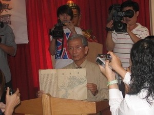 |
| Researcher Tran Dinh Son launched book on administrative map to the media. (Photo: Ha Huy Hiep/Vietnam+) |
(VOVworld) - Vietnam’s Buddhist Shangha has published a book of administrative maps from the time of King Quang Xi under the Qing Dynasty from 1875 to 1908. The book encloses a detailed map officially positioning Qiong Chau or Hainan Island as China’s furthest maritime border. The book was copied by Tran Dinh Ba who was Minister of Justice during the Khai Dinh Dynasty from 1916 to 1925. Ba kept the book at his house and handed it over to four generations with the fourth being researcher Tran Dinh Son who moved to Ho Chi Minh City in 1968. At the launching in Ho Chi Minh City on Tuesday, chief monk Thich Trung Hau, head of the Cultural Commission at the Vietnam Buddhist Shangha said that the launch aims to underline the Shangha’s view that Buddhists will do anything to benefit the nation, as well as practicing Buddha’s teachings. The book provides additional evidence confirming Vietnam’s sovereignty over the Hoang Sa, Paracel and Truong Sa, Spratly Archipelagos.