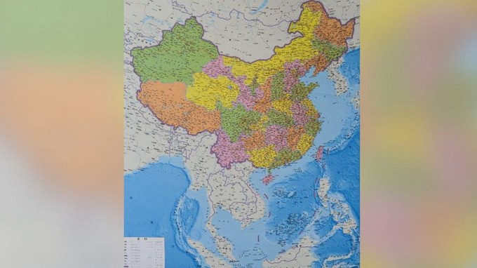
(VOVworld)- By publishing its 10-dash line map, China took another step toward realizing its ambition of monopolizing the East Sea. China’s unilateral action has been strongly condemned by the international community.
 |
On the new map published by China’s Hunan Map Publishing House on June 25, China brazenly claims sovereignty over the East Sea by emphasizing the “10-dash line” that deeply encroaches on the territorial waters of Vietnam, the Philippines, Malaysia, and Brunei. With the illegal boundary line, China puts nearly all of the East Sea including Vietnam’s Hoang Sa (Paracel) and Truong Sa (Spratly) archipelagos, the Philippine’s Palawan and Luzon islands, Scarborough shoal and even India’s Arunachal Pradesh under its sovereignty. China not only unilaterally claims its sovereignty over other countries’ archipelagos, it also says that the new official map is intended to defend its sovereignty and territorial integrity and provide the Chinese people with a comprehensive view of China’s territorial sovereignty. China intends to use the map in schools.
Irrational claims
The international community has been reacting to China’s attempt to monopolize the East Sea by re-drawing its map to include other countries’ territory. Several countries have strongly objected to the map saying that it reflects an ambition of unjustified expansion. They argue that China’s action runs counter to international law and the 1982 UN Convention on the Law of the Sea, to which China is a signatory. The US strongly denounced the map and criticized China for disregarding diplomatic means for settling disputes. India has also strongly protested saying the map represents a new Chinese land and sea invasion. India said that the Arunachal Pradesh state, which China includes on the map as part of Tibet, is an inseparable part of India’s territory and has been under New Delhi’s control since the two countries’ border war ended in 1962.
International media have criticized China’s map. The Washington Post on June 27 said the map shouldn't come as a surprise to China’s neighbors. In an article called “Beijing imposed unreasonable conditions in the East Sea” in France’s Le Monde newspaper, Brice Pedoletti wrote that becoming an ocean power is a key task of Chinese President Xi Jingping to realize the “Chinese dream”. To realize this dream, China appears willing to use any trick, flout international law and use its military superiority to intimidate smaller countries. According to Reuters, it’s difficult to believe China’s intentions are peaceful. The daily La Croix of France on June 26 said China is pursuing its ambition to dominate the East Sea and the East China Sea in order to compensate for internal instability.
China’s action has also received opposition from its own people. Chinese geopolitical commentator Wu Ge wrote on the Weibo social network that like China, the US, the UK or any other country could just to draw a new map to claim territory in other countries.
Disclosing hegemonic ambition
China has never been consistent about the vague origins of the so-called “9-dash line”. In fact, its explanations of the line have been extremely confused and contradictory. Chinese media, historians, lawyers, politicians and geologists have provided different and contradictory explanations of this line. In Chinese history, the “9-dash line” was once the “11-dash line”.
China’s efforts to establish its unfounded claim are tarnishing its international reputation. Claiming all of the archipelagos as its sovereign territory reveals China’s brazen hegemonic ambition. Whatever China says, the legal status of the 9-dash or 10-dash line will eventually be determined by an international arbitration court.