Vietnam deposits with UN baseline chart and coordinates in Gulf of Tonkin
(VOVWORLD) -Vietnam has deposited a nautical chart and a list of geographical coordinates related to the baseline used to determine the breadth of the territorial sea in the Gulf of Tonkin, the UN Secretary-General has just announced.
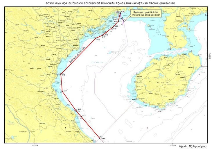 Chart of baselines for measuring the breadth of the territorial sea of Vietnam in the Gulf of Bac Bo (Tonkin). Photo: Ministry of Foreign Affairs Chart of baselines for measuring the breadth of the territorial sea of Vietnam in the Gulf of Bac Bo (Tonkin). Photo: Ministry of Foreign Affairs |
The UN Secretary-General’s notice on March 12, 2025, to member states stated that on 7 March 2025, the Socialist Republic of Vietnam deposited with the UN, pursuant to article 6, paragraph 2 of the 1982 United Nations Convention on the Law of the Sea, Chart (Chart of baselines for measuring the breadth of the territorial sea of the Socialist Republic of Vietnam in the Gulf of Bac Bo (Tonkin) showing straight baselines and outer limits of the territorial sea, as well as a list of geographical coordinates of points regarding “the baseline for measuring the breadth of the territorial sea of the mainland territory of Vietnam in the Gulf of Bac Bo”.
On March 14, 2025, the United Nations website published detailed information on the deposit at www.un.org/Depts/los.
The statement of the Government of Vietnam dated February 21, 2025, on the baselines for measuring the breadth of the territorial sea in the Gulf of Tonkin will be published in the next issue of the Law of the Sea Bulletin of the UN.