(VOVWORLD) - Vietnam has officially completed a chart and a list of geographic coordinates for a baseline for measuring the breadth of its territorial sea in the Gulf of Tonkin following notification from the United Nations. This reinforces Vietnam’s sovereignty and supports its economic development, reflecting its approach to strengthening its legal foundation in accordance with international law.
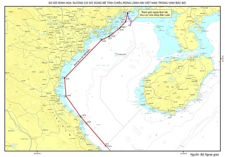 Chart illustrates the baselines used to calculate the width of Vietnam's territorial waters in the Gulf of Tonkin (Photo: Vietnamese Foreign Ministry) Chart illustrates the baselines used to calculate the width of Vietnam's territorial waters in the Gulf of Tonkin (Photo: Vietnamese Foreign Ministry) |
In an announcement last Wednesday, the UN Secretary-General acknowledged that Vietnam had deposited the chart and list of coordinates on March 7, pursuant to Article 16 Paragraph 2 of the 1982 United Nations Convention on the Law of the Sea (UNCLOS 1982).
Details have been published on the United Nations website (www.un.org/Depts/los) and in the official publication "Bulletin on the Law of the Sea".
Importance of defining baselines in the Gulf of Tonkin
Previously, Vietnam’s continental coastal baseline was defined in the Government's Declaration of November 12, 1982, which established 11 baseline points, ranging from Point 0 (the southwestern boundary of historical waters between Vietnam and Cambodia) to Point A11 (on Con Co Island, Quang Tri province). However, at the time of the issuance of the Declaration, Vietnam’s baseline in the Gulf of Tonkin had not been determined. According to Article 8 of Vietnam’s 2012 Law of the Sea, the Government is responsible for determining and announcing baselines in areas where they have not yet been established.
For coastal states like Vietnam, the absence of clear baselines can lead to indeterminate boundaries of waters, making it difficult to enforce immigration law, control epidemics, and manage anti-smuggling efforts.
By clearly defining baselines, coastal countries establish the boundaries of its waters, ensuring legitimate national interests while respecting the rights of other states under international law.
In the context of marine economic development and growing global maritime challenges, the completion of Vietnam’s baseline system is a critical step in clearly defining the boundaries of the country’s territorial waters under international law.
Vietnam’s baselines in accordance with international law
Vietnam's baseline system in the Gulf of Tonkin uses two methods: straight baselines and normal baselines. Straight baselines are established along Vietnam’s mainland coastal territory because the coastline on the Gulf of Tonkin is irregular and deeply indented, with many islands along the coast and the outermost islands and small rocks of Ha Long Bay forming a natural chain. Vietnam’s mainland baseline on the Gulf of Tonkin complies with Article 7 of UNCLOS which stipulates that, where the coastline is deeply indented or where there is a fringe of islands near the coast, straight baselines may be drawn joining appropriate points and used to measure the breadth of the territorial sea. Drawing straight baselines must not depart to any appreciable extent from the general direction of the coast, and sea areas lying within the lines must be sufficiently close to the land to be part of the regime of internal waters.
Normal baselines are used for Bach Long Vi Island. The baseline is drawn at the water line at lowest tide, in line with Article 5 of UNCLOS 1982, which stipulates that the normal baseline for measuring the breadth of the territorial sea is the low-water line along the coast as marked on large-scale charts officially recognized by the coastal State.
Vietnam's dual-method approach using straight baselines and normal baselines complies with Article 14 of UNCLOS, which allows coastal states to use a combination of methods for determining baselines (as prescribed in Articles 5 and 7) based on geographical conditions.
By defining its baselines in the Gulf of Tonkin, Vietnam reaffirms its commitment to UNCLOS, widely regarded as the "Constitution of the seas and oceans." Vietnam’s actions are in line with its international obligations and do not affect existing treaties to which it is a signatory, including UNCLOS and the Agreement on the Delimitation of the Gulf of Tonkin.
With this significant step, Vietnam strengthens the legal framework for exercising its sovereignty, sovereign rights, and jurisdiction rights in order to boost socio-economic development, strengthen sea management, and enhance international cooperation.